The Irish Grid System
|
|
The Irish Grid System |
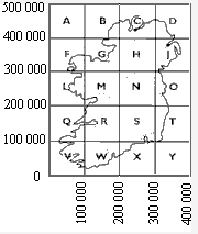
The Primary Irish Grid covers the country with a pattern
of squares which have 100 kilometre (100,000 metres) sides. Each square is
identified by a unique letter.
Grid references consist of a number of
digits made up of Eastings and Northings, Eastings being quoted first. For
example the most Northerly point in Ireland, Malin Head, has full Irish Grid
co-ordinates of 239873m East and 459924m North which locate it to the nearest
metre. The use of the square letter in grid references is optional. When the
letter is used the first digit of both co-ordinates (the ones which locate the
appropriate square) are dropped, Malin Head can therefore also be located by
grid reference C 39873 59924
The number of digits in a grid reference
depends on the scale of the map being used, the Primary Grid being further
sub-divided on maps as follows :-
Maps at 1:500 000 and 1:250 000 scale
have 10 kilometre squares. Malin Head can be found on these maps by first
locating the square 23 East and 45 North. And then by measurement or visual
estimation from the South West corner of the square go a further 9km East and
9km North. This will locate Malin Head to within 1km. The grid reference being
239 459 or C 39 59
Maps at 1:100 000, 1:50 000, 1:25 000 and 1:10
000 scale have 1 kilometre squares. Malin Head can be found on these maps
by first locating the square 39 East and 59 North. And then by measurement or
visual estimation from the South West corner of the square go a further 800m
East and 900m North. This will locate Malin Head to within 100m. The grid
reference being 2398 4599 or C 398 599
Maps at 1:2500 and 1:1250
scale have 100 metre squares. Malin Head can be found on these maps by
first locating the square 398 East and 599 North. And then by measurement or
visual estimation from the South West corner of the square go a further 70m
East and 20m North. This will locate Malin Head to within 10m. The grid
reference being 23987 45992 or C 3987 5992
Malin Head's (239873m
East and 459924m North) map reference at each scale is as follows:-
| Map Scale | Square Size | Grid Reference with square letter | Grid Reference without square letter |
| 1:500 000 1:250 000 |
10Km | C 39 59 | 239 459 |
| 1:100 000 1:50 000 1:25 000 1:10 000 |
1Km | C 398 599 | 2398 4599 |
| 1:2500 1:1250 |
100m | C 3987 5992 | 23987 45992 |